


Working with Maps
Maps—What For?
Maps are an integral part of all but very simple modeling projects. Their most obvious role is to provide a basis for convenient orientation in the model area. FEFLOW, however, makes much wider use of maps in the modeling workflow. Map geometries can be used to influence the mesh generation process, they can serve to geometrically define the target nodes, elements, edges or faces for parameter assignment, and attributed maps can even provide the input data themselves.
Supported File Formats
The  Maps panel
is used to load and manage raster and vector maps as well as database
connections.
Maps panel
is used to load and manage raster and vector maps as well as database
connections.
Supported vector maps
| Name of File Format | File Extension |
|---|---|
| ESRI Shape Files | *.shp |
| ASCII Point Files | *.pnt |
| ASCII Line Files | *.lin |
| ASCII Polygon Files | *.ply |
| FEFLOW Supermeshes | *.smh |
| DBase IV Files | *.dbf |
| ASCII Table Files | *.dat |
| FEFLOW XML Files | *.xml |
| MS Excel 97-2003 Files | *.xls |
| MS Excel Files | *.xlsx |
| DFS Files | *.dfs2 |
| AutoCAD Drawing Files | *.dwg |
| AutoCAD Exchange Files | *.dxf |
| Kitware File Formats | *.vtu, *.vtp |
| Kitware File Metadata | *.vtu, *.vtp |
| MIKE 21 Mesh Files | *.mesh |
| TetGen Surface Mesh Files | *.smesh |
| Autodesk 3DS Files | *.3ds |
| Triangle Polygon Files | *.poly |
| Object File Format Mesh Files | *.off |
| Object File Format Mesh Files | *.obj |
| STL Mesh Files | *.stl |
Supported vector maps - 3D Geological Models
| Name of File Format | File Extension |
|---|---|
| Leapfrog Mesh Files | *.lfm |
| GeoModeller 3D Files | *.gmod |
| GOCAD 3D Model Files | *.ml |
| GOCAD Surface Files | *.ts |
Supported raster maps
| Name of File Format | File Extension |
|---|---|
|
Windows Bitmap Files |
*.bmp |
| Geo-TIFF Files | *.tiff |
| Geo-JPEG Files | *.jpg |
| Portable Network Graphics Image Files | *.png |
Raster Maps/Maps Containing Data
We have to distinguish between raster maps and maps which contain data. Data can be provided in the form of tables or as vector maps if they contain geometry information.
Pixel-based raster maps in formats such as *.tiff, *.jpeg, *.png, or *.bmp can only provide visual information. Vector maps contain discrete geometries (points, lines, and polygons). Formats supported by FEFLOW 8.1 include ESRI Shape Files, AutoCAD Exchange Files, DBase Tables, and several ASCII (text) file formats. In addition to geometrical information these file formats also encompass attribute data, i.e., numerical and/or textual information related to certain geometrical features. While some formats like *.shp support an unlimited number of user-defined attributes, others like *.dxf only allow drawing attributes such as color or line style, and very simple formats such as *.trp (ASCII triplet format—XYF) only support one single attribute value.
Geodatabases
Besides the possibility to load separate maps
of various file formats, FEFLOW
8.1
also provides the option to connect to different types of geographical
databases for data import via the Maps panel and export via the
Data panel
and View
Components panel. The following database systems are supported:
- PostGIS
- Oracle
- ESRI Geodatabase
Further details are presented in section Geodatabases.
Microsoft Excel Worksheets and Access Tables
Tabular data from Microsoft Excel worksheets and Microsoft Access databases can be imported into FEFLOW 8.1 as maps. Export of parameter values and chart data into Excel and Access is supported as well. Supported import and export formats include *.xls, *.xlsx, *.mdb and *.accdb.
Each Excel worksheet needs to be imported as a separate map. For workbooks containing multiple worksheets, the worksheet to be imported is selected via an import dialog.
The import of tables from Microsoft Access databases works similarly. After selecting a database, each table needs to be imported as a separate map via a selection dialog.
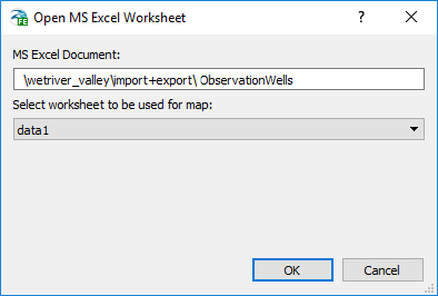
Selecting worksheets for import from a MS Excel workbook.
Exported data can either be added as new worksheets or tables to an existing Excel workbook or Access database or they can replace an existing worksheet or table.